
Most people who visit the Khmer ruins of Buriram see Phanom Rung and Mueang Tam — and leave satisfied. Those are extraordinary sites. But they are two points on a map that once held dozens.
The Khmer empire stretched across what is now Buriram province for centuries. It built temples, hospitals, rest-houses and reservoirs. It cut a royal highway through the region connecting Angkor to its northern capital at Phimai. When the empire contracted and the roads fell quiet, it left behind more Khmer ruins in Buriram than most people realise — and almost none of it appears in any English-language guide.
This is the rest of the picture.
Why Buriram Has So Many Khmer Ruins
Buriram sits in the heart of the territory the Khmer controlled between roughly the ninth and thirteenth centuries. The province’s geography — a plateau of red laterite soil, volcanic hills, and river systems feeding south toward Cambodia — made it strategically and spiritually significant. The extinct volcanoes provided stone for building and commanding views for temples. The rivers provided water for the vast reservoirs the Khmer used to sustain settlements through the dry season.
The result is a province scattered with prasat — Khmer sanctuaries — ranging from major temple complexes to single-tower ruins half-buried in paddy fields. Most have no official signposting. Some are inside temple grounds. A few require asking a local to point the way.
For background on the Khmer empire’s presence in this region, the Phanom Rung and Mueang Tam articles cover the history in full. This guide focuses on what lies beyond those two.
Jayavarman VII and the Building Programme
The most prolific builder in Khmer history was Jayavarman VII, who ruled from approximately 1181 to 1218. His reign produced an extraordinary infrastructure programme across the empire: 102 hospitals (arogayasalas), 17 rest-houses (dharmasalas) along the royal road to Phimai, and countless temples dedicated to his parents and Mahayana Buddhist deities.
In Buriram, several of the lesser-known Khmer ruins date to this period. The arogayasalas follow a consistent plan — a central tower, a small library building, a surrounding wall and moat. Each was positioned along a major route. The dharmasalas were built at intervals of roughly 15–20 kilometres along the Angkor–Phimai royal road. They provided shelter for travellers, pilgrims and soldiers moving between the empire’s capitals.
Understanding this building programme is the key to reading these ruins. A small laterite tower in a rice field is not a random curiosity — it is a hospital, or a waypoint on a medieval highway, and it was part of one of the most ambitious construction projects of the pre-modern world.
Kuti Ruesi Ban Khok Mueang
District: Prakhon Chai | Distance from Mueang Tam: 3.5km
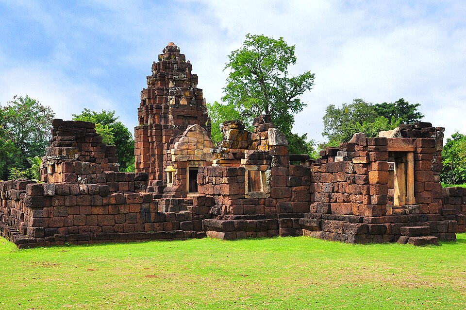
The easiest addition to a Mueang Tam visit is this well-preserved arogayasala just 3.5 kilometres away. Kuti Ruesi Ban Khok Mueang is one of the more complete of Jayavarman VII’s hospital complexes still standing in Buriram. It has a central laterite tower topped with a lotus-bud finial, an intact library building, enclosure wall, and a pond that would once have supplied the hospital. The carvings are unusually detailed for laterite construction.
The site sits quietly off the main road with little to announce it. In fact, there are no coaches, no entrance fee, and often no other visitors. Even after a morning at Mueang Tam, the stillness here feels different — no entrance booth, no other cars, nothing to announce the place at all.
For anyone already making the Phanom Rung–Mueang Tam circuit, this adds thirty minutes and almost no extra distance.
Kuti Ruesi Ban Nong Bua Rai
District: Prakhon Chai | Location: Foot of Phanom Rung mountain
A second arogayasala sits at the foot of the hill below Phanom Rung — the point from which pilgrims would have begun the processional approach to the temple above. Kuti Ruesi Ban Nong Bua Rai has a central prang in good condition with the lotus-bud top intact, a library building, and a surrounding enclosure. The carvings are extensive.
The position is historically resonant: this was part of the sacred approach to one of the most important temples in the Khmer world. Pilgrims coming from Angkor would have passed through this hospital complex before climbing to Phanom Rung. Most visitors today drive straight to the car park at the top without knowing it exists.
Prasat Nong Hong
District: Non Din Daeng | Condition: Standing three-prang complex
Prasat Nong Hong is among the most intact three-prang complexes in Buriram province — three brick towers on a shared laterite base, with carved lintels depicting Hindu deities including Vishnu and Indra. The towers have the square indented form typical of tenth and eleventh-century Khmer construction, and the site retains its original U-shaped moat.
Non Din Daeng district is in the southeast of Buriram, close to the Cambodian border — the direction from which the Khmer empire originally came. The positioning of Prasat Nong Hong near the Lam Nang Rong reservoir places it in what was once a well-provisioned stretch of the Khmer-controlled plateau. The area is little visited by foreign tourists, and the ruins have an authenticity that more accessible sites sometimes lack.
The lintels in particular reward close attention: the carvings here represent a quality of workmanship that was once replicated in hundreds of temples across the region.
Prasat Khao Plai Bat I and II
District: Lahan Sai | Status: UNESCO Tentative List | Admission: 100 baht per site — verify on arrival
Prasat Khao Plai Bat stands on the slopes of an extinct volcano in Lahan Sai district — the same volcanic geology that produced Phanom Rung, some 30 kilometres to the west. The two sites (designated I and II, separated by a short distance) date to the tenth century and their architectural plan closely follows that of Phanom Rung itself. Both are on Thailand’s UNESCO Tentative List as part of the same Khmer temple ensemble as Phanom Rung and Mueang Tam.
Site II carries an extraordinary story that most visitors never hear.
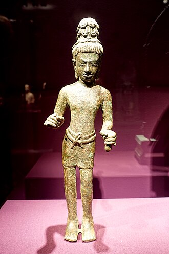
In 1964, workers excavating at Prasat Khao Plai Bat II uncovered a cache of Buddhist bronze sculptures dating to the eighth and ninth centuries. It was the most significant find of its kind anywhere in Southeast Asia. The statues had been buried, perhaps deliberately hidden, beneath the temple floor. They included bodhisattva figures of exceptional quality and several Buddha images.
As a result, the bronzes were dispersed. Some went to the Bangkok National Museum, where they remain today. Others found their way to European collections — the Rijksmuseum in Amsterdam acquired pieces, as did the Musée Guimet in Paris. In 2024 and 2025, four of the sculptures were repatriated to Thailand.
The temple that held them for over a thousand years is still there, under active conservation, on a quiet hillside in Lahan Sai.
Prasat Wat Khok Ngio
District: Pakham | Access: Highway 348, southwestern Buriram
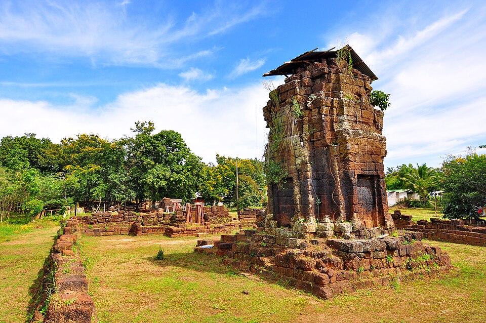
The furthest reach of this guide is Prasat Wat Khok Ngio in Pakham district, near Buriram’s border with Nakhon Ratchasima. This is the only Khmer arogayasala in the southwestern corner of the province. It is an eleventh-century complex built in the Baphuon style, with a laterite central tower, a library, front and rear gopura, and a U-shaped moat.
The site is genuinely remote. Pakham district receives almost no foreign visitors, and the ruin sits on Highway 348 without the infrastructure of the major sites. What it offers in exchange is solitude and the sense of finding something that the tourist trail has not yet reached. The central tower is still standing. The moat is largely intact. The surrounding countryside — flat rice fields, distant hills — looks much as it would have to a Khmer pilgrim making their way along this route nine hundred years ago.
This is a site for those who already know the major ruins and want to go further.
The Royal Road: Buriram’s Dharmasalas
Running roughly northwest through Buriram — from the Cambodian border toward the great Khmer sanctuary at Phimai in Nakhon Ratchasima — is the trace of a medieval highway. This was the royal road from Angkor to Phimai, one of the most important routes in the Khmer empire.
Jayavarman VII built 17 rest-houses along its Thai section, spaced at regular intervals. Each dharmasala was a simple stone building — a shelter, not a temple — providing accommodation and provisions for the travellers and officials who moved between the empire’s administrative centres.
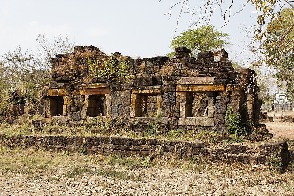
Several of these rest-houses once stood in Buriram province. Most are now rubble, isolated in rice fields, unmarked and unvisited. For example, Prasat Ban Bu, at the foot of the Phanom Rung approach, is one of the more identifiable: a low laterite structure beside the road, its walls partially standing. Others — Prasat Nong Kong, Prasat Nong Plong — survive as fragments requiring determined searching to find.
The dharmasalas are not destinations in the conventional sense. However, knowing they exist changes the way you read the landscape. The red laterite fragments in a field beside the road are not random debris — they mark the line of a highway that once carried the armies and administrators of one of the world’s great empires.
Planning Your Visit to Buriram’s Khmer Ruins
The lesser Khmer ruins in Buriram fall naturally into day trip combinations:
With Mueang Tam: Add Kuti Ruesi Ban Khok Mueang (3.5km away) to any Mueang Tam visit. Negligible extra distance.
With Phanom Rung: Stop at Kuti Ruesi Ban Nong Bua Rai at the foot of the hill on your way up or down.
Lahan Sai circuit: Prasat Khao Plai Bat I and II are worth a dedicated half-day, combined with Phanom Rung for a full day in the eastern part of the province.
Non Din Daeng: Prasat Nong Hong is further east and suits those exploring the less-visited southeastern quarter of Buriram — potentially combined with a visit toward the Cambodian border area.
Wat Khao Angkhan: The Buddhist hilltop temple 20 kilometres from Phanom Rung fits naturally into any southern Buriram day — ancient Dvaravati sema stones, panoramic views, free entry. Full guide to Wat Khao Angkhan.
Pakham: Prasat Wat Khok Ngio requires a separate journey to the southwest and is best treated as a standalone excursion for those specifically interested in the Baphuon period.
A hired car makes visiting multiple sites straightforward. However, public transport reaches the districts but not the ruins themselves.
Compare car hire rates for Buriram
Where to stay: for the southern sites around Phanom Rung and Mueang Tam, Nang Rong makes a practical base; for everything else, Buriram city has the widest choice. Our guide to where to stay in Buriram covers both.
Practical Notes on Visiting Buriram’s Khmer Ruins
Access and opening hours for the lesser sites are inconsistent. Phanom Rung and Mueang Tam have staffed entrances with fixed hours (6:00–18:00) and clear signposting. The smaller sites vary: some are within active temple grounds and accessible during daylight hours; others sit on unfenced land and are simply there. Admission fees, where they exist, are typically 50–100 baht — verify on arrival as these can change.
Furthermore, most of the sites in this guide have no English-language signage and some have minimal Thai signage. GPS coordinates for the well-known sites are available in Google Maps by searching the Thai name. For the dharmasalas, local knowledge or a Thai-language map is helpful.
The roads throughout Buriram are generally good. A standard car handles all the routes in this guide — no four-wheel drive required.
Before You Go
A long day exploring Khmer ruins in the Buriram countryside is one of the best days this province offers. Travel insurance is worth having.
Get a travel insurance quote for Thailand
Feature image: Ddalbiez, CC BY-SA 3.0 via Wikimedia Commons
Kuti Ruesi Ban Khok Mueang: Warawut Srisopark, CC BY-SA 3.0 via Wikimedia Commons
Prasat Wat Khok Ngio: Warawut Srisopark, CC BY-SA 3.0 via Wikimedia Commons
Prasat Ban Bu: Ddalbiez, CC BY-SA 3.0 via Wikimedia Commons
Buriram Live covers the real Buriram — temples, football, motorsport, rural life and practical information for visitors and those with deeper connections to the region. No fluff, no sponsored itineraries. Follow Buriram Live on Facebook for new articles and updates.
This article contains affiliate links. If you make a purchase through a link on this page, we may earn a small commission at no extra cost to you.


Get Buriram updates by email
Occasional emails when there is something worth knowing: new guides, festival and MotoGP dates, and Buriram United news. No spam, and you can unsubscribe at any time.
We will email you a link to confirm. See our privacy policy.